Free CSS Navigation Menu Designs 2 at exploding-boy.com

Mandya

Mandya was part of Mysore District, Mandya extends from 76 19' - 76 20' South and 12 13' - 13 4' East & is about 2500 - 3000 ft above the Sea level. District has five 
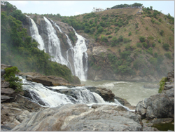
important rivers, river Cauvery & its four tributories Hemavathi, Shimsha, Lokapavani, Veeravaishnavi.The main water resource is river Cauvery, supplied to the district through Krishna Raja Sagar dam(KRS dam located in Srirangapatna Taluk), Agriculture forms the main occupation. Sugarcane & Paddy are grown in abundance & the district has 3 Sugar Factories. The Yoganarasimha temple up on the hill offer stunning view of the hills and valleys.

Back

Tourist places around Bangalore

Mandya Hesaraghatta Chamundi Hills The Big Banyan Tree  

 Srirangapatnam Murudeshwar Bannerghatta National Park  

 Brindavan Gardens


| Home  | About Bangalore | History |Important places | How to Reach | Where to stay | Tourist Info | Online Enquiry  | Contact Us  |

Our Group Portals

| OmArunachala.com | AnjaneyaSwami.com | SaidaiMart.com | VelloreCity.com |

 | MyBaby.co.in | ChennaiWebDirectory.com | ChennaiJobsOnline.com | Southindiatourism.info |

 | Ranipet.in | Pudhucherry.info | TamilNadumlas.com | TVmalai.in | Livechennai.com|

Powered By : J B Soft System, Chennai-15